Why India Building Roads On LAC ? The 1962 Lesson It Took 60 Years to Act On
In September 2025, Prime Minister Modi stood in Arunachal Pradesh to break ground on a 1,748 km highway that will run within 20 km of the Chinese border. China objected. The question of why India building roads on LAC has a simple answer the 1962 war and a more complicated one involving six decades of delay, bureaucratic paralysis, and a strategic awakening that the 2020 Galwan Valley clash finally forced. This is the story of India’s most ambitious border infrastructure push, what it is trying to achieve, and why China is alarmed.
The 1962 Wound That Shaped Everything
In October 1962, Chinese forces swept through the Himalayan passes into Arunachal Pradesh and Ladakh in a war that lasted one month and ended in a humiliating Indian defeat. The reasons for the collapse were many, poor intelligence, political miscalculation, underprepared troops. But one reason stood above the rest: India had no roads.
The Indian Army could not move men or equipment fast enough to respond to the Chinese advance. Supply lines were nonexistent in the high-altitude terrain. Soldiers were fighting at 14,000 feet with inadequate gear, no reinforcements, and no way to evacuate the wounded. The Chinese, by contrast, had spent years building roads through Tibet including directly to the LAC before the war began. They had studied the terrain. India had not.
After the ceasefire, something extraordinary happened: India decided not to build roads near the border. The reasoning, which sounds absurd in hindsight, was that roads near the border would help the Chinese advance faster in a future war. India chose vulnerability as a strategy. For nearly four decades, this logic perverse as it was guided border infrastructure policy. The areas closest to China remained the areas least connected to India.
What Changed: Galwan 2020 and the Reckoning
The real turning point was not 1962. It was June 15, 2020, when Indian and Chinese soldiers clashed with stones, clubs and iron rods in the Galwan Valley in Ladakh. Twenty Indian soldiers were killed the first deaths on the LAC in 45 years. What the clash revealed was as alarming as the casualties themselves: China had been quietly building infrastructure on its side of the LAC for years, and India had not kept pace.
Satellite imagery released after Galwan showed Chinese villages, roads, and military facilities constructed right up to the Indian-perceived border in eastern Ladakh. China had moved the effective line of control through infrastructure building roads, then helipads, then staging areas, then permanent posts. By the time India noticed, the facts on the ground had changed.
The government’s response after Galwan was unlike anything that had come before. The Border Roads Organisation (BRO) was given emergency powers, fast-tracked clearances, and a budget that tripled in three years. Projects that had been stuck in environmental and forest clearance for a decade were approved within months. The calculation had reversed completely: roads near the border were no longer a liability. They were an existential necessity.
What India Is Building: The Scale of the Push
The infrastructure push since 2020 is genuinely unprecedented in scale. Here is what has been completed or is underway:
| Project | Scale | Cost | Status |
| Arunachal Frontier Highway | 1,748 km along LAC | Rs 40,000 crore | 2029 (revised) |
| Sela Tunnel, Arunachal | 13 km twin tunnel | Rs 700 crore | Completed 2024 |
| Shyok Tunnel, Ladakh | 920 m cut-and-cover | Part of BRO package | Completed Dec 2025 |
| Darbuk-DBO Road, Ladakh | 255 km all-weather | Part of ICBR-I | Completed 2020 |
| 125 BRO projects (Dec 2025) | 28 roads, 93 bridges | Not disclosed | Completed Dec 2025 |
| ICBR Phase III | 104 roads, 6,700 km | Part of BIMF | Ongoing from 2020 |
BRO = Border Roads Organisation. ICBR = India-China Border Roads. BIMF = Border Infrastructure and Management Fund.
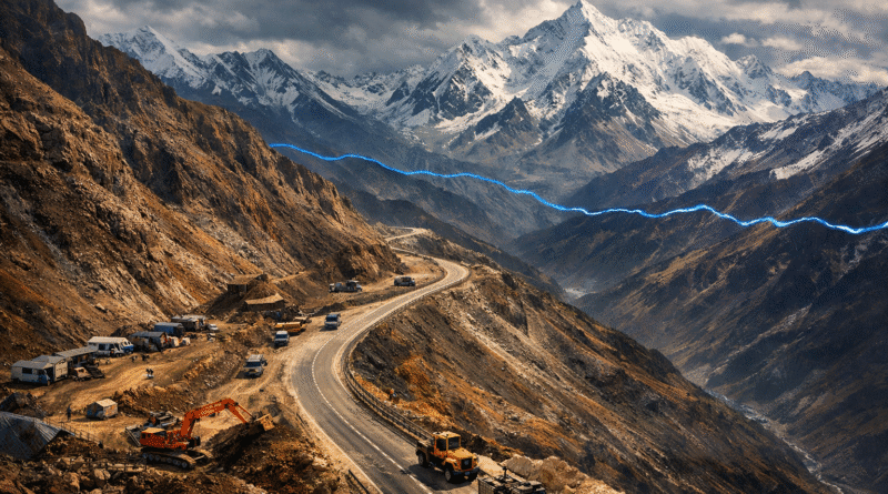
The centrepiece is the Arunachal Frontier Highway officially NH-913 which will run from Bomdila in the northwest of Arunachal Pradesh all the way to Vijaynagar near the Myanmar border in the southeast, passing through Tawang, Tuting, Mechuka, Dibang Valley, and Kibithu. At 1,748 km it will be the longest highway built in one go in Indian history. Running within 20 km of the LAC throughout its length, it will give the Indian Army direct lateral mobility across the entire eastern border for the first time the ability to move troops and equipment from one valley to another without dipping down into Assam.
The Sela Tunnel, completed in 2024, solved a specific and dangerous vulnerability. The Sela Pass at 13,700 feet was the only road access to Tawang, the strategically vital district that borders Bhutan and sits adjacent to the area China claims as “South Tibet.” In winter, the pass was often blocked for months. An attacking force could cut off Tawang simply by timing its advance to the winter snowfall. The twin-tube tunnel bypasses the pass entirely, keeping the route open year-round.
In December 2025, Defence Minister Rajnath Singh inaugurated 125 projects in a single ceremony 93 bridges, 28 roads, and 4 miscellaneous works across seven states and two union territories. The Shyok Tunnel in Ladakh, inaugurated that day, provides all-weather access through avalanche-prone terrain to forward positions near the Chinese border.
Why China Is Alarmed and What It Is Doing in Response
China objected to the Arunachal Frontier Highway as soon as it received preliminary approval in 2014. Its Foreign Ministry said India should “refrain from taking any actions that could further complicate the situation.” Beijing’s concern is not hard to understand. The highway changes the military balance in the eastern sector fundamentally.
Until now, Chinese forces had a structural advantage in Arunachal Pradesh: India’s valleys run north-south, meaning troops in one valley could not quickly reinforce another. To move from Tawang in the west to Dibang Valley in the east, Indian forces had to travel hundreds of kilometres south into Assam and then back up. A lateral highway along the LAC eliminates that constraint entirely. India will be able to shift troops from one threatened point to another within hours rather than days.
China’s response on its own side has been equally aggressive. It has constructed the G219 and G315 highways in Tibet, which allow rapid force movement across the entire length of the LAC. It has built staging areas and helipads near the LAC in Ladakh, Arunachal Pradesh, and Sikkim. In the Shaksgam Valley — territory Pakistan ceded to China in 1963. China has been extending roads toward the LAC’s western edge. In January 2026, it reasserted its claim over the Shaksgam Valley through new infrastructure development, triggering a formal protest from India’s Ministry of External Affairs.
Both sides are essentially building the infrastructure for a war neither officially wants. The race is about deterrence each side trying to ensure that the cost of aggression is higher than the potential gain.
The 1962 Question: Is It Too Late?
Arunachal Pradesh Chief Minister Pema Khandu put it directly: “1962 was history and will never be repeated. In 1962, infrastructure in the region was very poor. Today, we are not what we were in 1962.”
That confidence is at least partially earned. India has completed all-weather road access to areas that were entirely cut off a decade ago. The Sela Tunnel means Tawang can be reinforced in winter. The Darbuk-Shayok-DBO road in Ladakh means India’s highest airstrip at Daulat Beg Oldie 16,614 feet is now accessible by road year-round. These are genuine strategic achievements.
But the honest assessment is more complicated. China still holds significant infrastructure advantages in Tibet. The Qinghai-Tibet railway reaches Lhasa, and its extensions toward the LAC mean China can move heavy equipment and large troop numbers far faster than India can. India’s terrain is harder the valleys that make Arunachal Pradesh so beautiful also make construction extraordinarily difficult and expensive. The revised completion date for the Frontier Highway has already slipped from 2027 to 2029.
The gap has narrowed considerably since 2020. It has not closed. What India has achieved is a shift from the catastrophic vulnerability of 1962 to a competitive disadvantage that can be managed. Whether that is enough depends on whether the deterrence holds and on whether the political will that drove this infrastructure push survives the bureaucratic attrition that delayed it for six decades.
ThirdPol’s Take
The lesson of 1962 is not just that India lost a war. It is that India lost a war it did not have to lose, because it chose not to prepare for it. The decision to avoid building roads near the border justified at the time as a strategic calculation was one of the most costly errors in post-independence Indian history. The infrastructure push since 2020 is India finally paying that debt. It is expensive, it is late, and it is still incomplete. But the direction is right. The Arunachal Frontier Highway, when finished, will be one of the most consequential strategic assets India has ever built not because it will win a war, but because it makes a war far less likely. That is what deterrence looks like in the Himalayas: not missiles, but roads.
By Amit Mangal | ThirdPol | April 2026